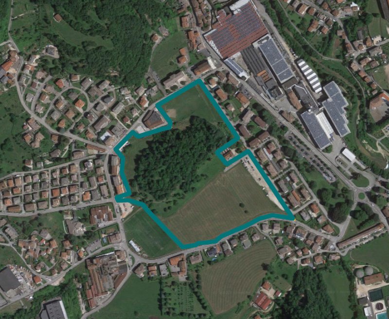
Building area in Valdagno (VI)
Via Divisione Julia/Via L. Marzotto/Via Battaglione Monte Berico
This is an area of 77,664 square meters located on the outskirts of the town of Valdagno, partly urbanized with primary and secondary infrastructure, in the center of which there is a wooded hill, urbanistically linked to the maintenance of greenery with public interest, The remaining portion currently cultivated with temporary contracts, is subject to redevelopment and partial renovation.
The area falls into the zone Partly in the zone "new residential areas" and partly agricultural land. Technical rules of implementation and indices: Urbanistically the entire area of the estate "the Grumo" is classified in the area "new residential areas" in the Z.T.O. C2, the land plots on folio 7 mapping 1222 - 1224 1226 - 403 and 50% of the 460 map are buildable, in peripheral residential area for a total area of sqm. 37.019 The remaining areas are agricultural land. The validity of the PUA is subject to the indications and forecasts contained therein.
If the PUA lapses before the forecast is made, the following applies. The maximum permitted volume is 52,000 mc. The permissible type is that of block, tower, inline and row buildings; the use of a single type for the entire area is not allowed.
It’s impossible to change the area above 302 meters above sea level. 20% of the maximum allowable volume is allocated to conventionally owned buildings. An additional standard of 33,864 m2 (F3/94-016) is transferred to the Municipality, as identified in the IP maps.
The land is listed in the Land Registry of the Municipality of Valdagno al Foglio 7:
Particelle 216 - 217 - 219 - 220 - 221 - 222 - 223 - 224 - 225 - 226 - 229 - 230 - 403 - 459 - 460 - 778 - 779 - 1222 - 1224 - 1226
自动翻译所用的语言
Area edificabile a Valdagno (VI)
Via Divisione Julia/Via L. Marzotto/Via Battaglione Monte Berico
Trattasi di un’area di di 77.664 mq ubicata nella immediata periferia del comune di Valdagno, in parte urbanizzata con infrastrutture primarie e secondarie, nel cui centro è presente una collina boschiva, urbanisticamente vincolata al mantenimento del verde con interesse pubblico, la restante porzione in parte attualmente coltivata con contratti temporanei, è soggetta a riqualificazione e parziale trasformazione edilizia.
L'area ricade in zona In parte in zona "nuove zone residenziali" ed in parte terreni agricoli. Norme tecniche di attuazione ed indici: Urbanisticamente l’intera area della tenuta “il Grumo” è classificata in zona “nuove zone residenziali” in ambito Z.T.O. C2, i terreni al foglio 7 mappali 1222 – 1224 1226 – 403 ed il 50% del mappale 460 risultano edificabili, in ambito residenziale periferico per una superficie complessiva di mq. 37.019 Le restanti zone sono terreni agricoli. Nell’arco di validità del PUA sono fatte salve le indicazioni e le previsioni in esso contenute.
Qualora il PUA decadesse prima della realizzazione delle previsioni, si applica quanto di seguito riportato. Il volume massimo ammesso è di 52.000 mc. La tipologia ammessa è quella degli edifici a blocco, a torre, in linea e a schiera; non è ammesso l’utilizzo di una unica tipologia per l’intera area.
E’ inedificabile l’area posta sopra la quota di 302 metri sul livello del mare. Il 20% del volume massimo ammissibile è destinato ad edilizia convenzionata. Viene ceduto al Comune uno standard integrativo di 33.864 mq (F3/94-016) così come individuato nella cartografia del PI.
I terreni risultano censiti al Catasto Terreni del Comune di Valdagno al Foglio 7:
Particelle 216 - 217 - 219 - 220 - 221 - 222 - 223 - 224 - 225 - 226 - 229 - 230 - 403 - 459 - 460 - 778 - 779 - 1222 - 1224 - 1226


