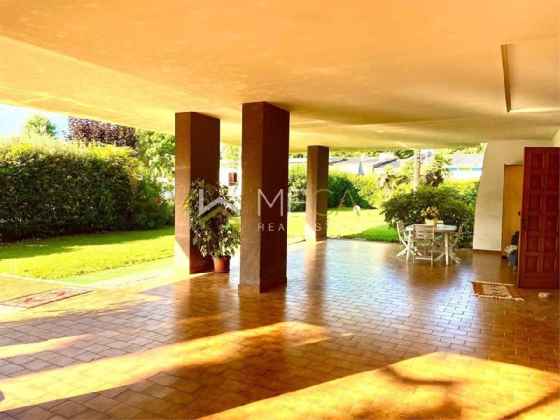
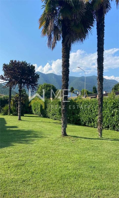
Gavardo, in a central location convenient to all services, schools and shops, large detached villa with adjoining building land.
It is possible to purchase the villa separately from the building land.
The private garden of the villa measures approximately 600 square meters, the porch approximately 83 square meters.
The villa is divided into two floors on which there are two separate apartments:
ground floor apartment recently renovated with living room, kitchen, two bathrooms and two bedrooms;
first floor apartment with dining room and access to the terrace of over 52 square meters, kitchen, four bedrooms and two bathrooms.
Basement with garage, cellar and accessory rooms.
The price refers to the villa with its appurtenances and adjacent building land.
Gavardo
Gavardo is located at the entrance to the Valle Sabbia at an average altitude of 199 m above sea level. (the lowest point in the municipal territory is 184 m above sea level and the highest is 877 m above sea level); the town is mainly hilly, with the presence of some mountains that enclose the town to the north and east. The town is crossed by the Chiese river, by the Naviglio Grande Bresciano - which rises to the north of the town and has ancient origins, in fact it was exploited by the Benedictine monks to power the mills and by the Vrenda torrent, which descends from Vallio Terme and flows into the Chiese in the hamlet of Sopraponte. Gavardo is included between some mountains such as Monte Budellone and Colle di San Martino to the southwest, the Tre Cornelli to the west, Monte Magno to the north and the hills of morainic origin that extend to the east, towards Muscoline and Benaco. seismic: zone 2 (medium-high seismicity), PCM Ordinance n. 3274 of 20/03/2003. Climate The climate is attributable to that of the pre-Alpine area, with rather harsh winters and hot and muggy summers, even if the latter are cooler on the high ground thanks also to the fresh winds that blow from Vallio Terme, Vrenda, which descends from Vallio Terme and flows into the Chiese in the hamlet of Sopraponte. Gavardo is included between some mountains such as Monte Budellone and Colle di San Martino to the south west, Tre Cornelli to the west, Monte Magno to the north and the hills of morainic origin that extend to the east, towards Muscoline and Benac in particular during the night. Precipitation is quite frequent and fairly abundant (around 1200 mm/year) and in the winter months it also becomes snowy. Despite its proximity to Lake Garda, the town is unable to enjoy its benefits as the morainic hills limit its influences.
自动翻译所用的语言
Gavardo, in posizione centrale comoda a tutti i servizi, scuole e negozi, villa singola di dimensioni importanti con annesso terreno edificabile.
Possibile acquistare la villa separatamente dal terreno edificabile.
Il giardino privato della villa misura circa 600 mq, il porticato circa 83 mq.
La villa è divisa su due piani sui quali sono presenti due appartamenti distinti :
appartamento al piano terra ristrutturato recentemente con sala, cucina abitabile, due bagni e due camere;
appartamento al primo piano con salone da pranzo e accesso alla terrazza di oltre 52 mq, cucina abitabile, quattro camere e due bagni.
Piano interrato con garage, cantina e locali accessori.
Il prezzo è relativo alla villa con relative pertinenze e terreno edificabile adiacente.
Gavardo
Gavardo si trova all'imbocco della Valle Sabbia ad un'altitudine media di 199 m s.l.m. (il punto più basso nel territorio comunale si trova a 184 m s.l.m. e quello più alto a 877 m s.l.m.); il paese è prevalentemente collinare, con la presenza di alcuni monti che racchiudono il paese a nord e a est. Il comune è attraversato dal fiume Chiese, dal Naviglio Grande Bresciano - che nasce a nord del paese e che ha un'origine antica, infatti veniva sfruttato dai monaci benedettini per alimentare i mulini e dal torrente Vrenda, il quale scende da Vallio Terme e sfocia nel Chiese nella frazione di Sopraponte. Gavardo è compreso tra alcuni monti quali il Monte Budellone e il Colle di san Martino a sud ovest, i Tre Cornelli a ovest, il Monte Magno a nord e le colline di origine morenica che si estendono a est, verso Muscoline e il Benaco. sismica: zona 2 (sismicità medio-alta), Ordinanza PCM n. 3274 del 20/03/2003. Clima Il clima è riconducibile a quello zona prealpina, con inverni piuttosto rigidi ed estati calde e afose, anche se queste ultime sono più fresche sulle alture grazie anche ai venti freschi che soffiano da Vallio Terme,Vrenda, il quale scende da Vallio Terme e sfocia nel Chiese nella frazione di Sopraponte. Gavardo è compreso tra alcuni monti quali il Monte Budellone e il Colle di san Martino a sud ovest, i Tre Cornelli a ovest, il Monte Magno a nord e le colline di origine morenica che si estendono a est, verso Muscoline e il Benac in particolare durante la notte. Le precipitazioni sono abbastanza frequenti e discretamente abbondanti (attorno ai 1200 mm/anno) e nei mesi invernali diventano anche nevose. Nonostante la vicinanza al lago di Garda, il paese non riesce a goderne dei benefici in quanto le colline moreniche ne limitano gli influssi.
CLASSE ENERGETICA: In fase di valutazione
Gavardo, in zentraler Lage mit bequemer Anbindung an alle Dienstleistungen, Schulen und Geschäfte, große freistehende Villa mit angrenzendem Baugrundstück.
Es besteht die Möglichkeit, die Villa separat vom Baugrundstück zu erwerben.
Der private Garten der Villa misst ca. 600 m2, die Veranda ca. 83 m2.
Die Villa ist in zwei Etagen aufgeteilt, auf denen sich zwei separate Wohnungen befinden:
kürzlich renovierte Erdgeschosswohnung mit Wohnzimmer, Küche, zwei Badezimmern und zwei Schlafzimmern;
Wohnung im ersten Stock mit Esszimmer und Zugang zur Terrasse von über 52 m2, Küche, vier Schlafzimmern und zwei Badezimmern.
Keller mit Garage, Keller und Nebenräumen.
Der Preis bezieht sich auf die Villa mit dazugehöriger Ausstattung und angrenzendem Baugrundstück.
Gavardo
Gavardo liegt am Eingang des Valle Sabbia auf einer durchschnittlichen Höhe von 199 m über dem Meeresspiegel. (der tiefste Punkt im Gemeindegebiet liegt auf 184 m ü. NHN und der höchste auf 877 m ü. NN); Die Stadt ist überwiegend hügelig, mit einigen Bergen, die die Stadt im Norden und Osten umgeben. Die Gemeinde wird vom Fluss Chiese und vom Fluss Naviglio Grande Bresciano durchflossen, der im Norden der Stadt entspringt und einen antiken Ursprung hat. Tatsächlich wurde er von den Benediktinermönchen genutzt, um die Mühlen anzutreiben, und vom Bach Vrenda entspringt Vallio Terme und fließt in Chiese im Weiler Sopraponte. Gavardo liegt zwischen einigen Bergen wie dem Monte Budellone und dem Colle di San Martino im Südwesten, den Tre Cornelli im Westen, dem Monte Magno im Norden und den Hügeln moränischen Ursprungs, die sich im Osten in Richtung Muscoline und Benaco erstrecken. seismisch: Zone 2 (mittlere bis hohe Seismizität), PCM-Verordnung Nr. 3274 vom 20.03.2003. Klima Das Klima lässt sich auf das des Voralpengebiets zurückführen, mit ziemlich strengen Wintern und heißen, schwülen Sommern, auch wenn letztere auf den Hügeln dank der frischen Winde, die aus Vallio Terme und Vrenda wehen, kühler sind entspringt Vallio Terme und fließt in Chiese im Weiler Sopraponte. Gavardo liegt zwischen einigen Bergen wie dem Monte Budellone und dem Colle di San Martino im Südwesten, den Tre Cornelli im Westen, dem Monte Magno im Norden und den Hügeln moränischen Ursprungs, die sich im Osten, insbesondere in Richtung Muscoline und Benac, erstrecken während der Nacht. Die Niederschläge sind recht häufig und ziemlich reichlich (ca. 1200 mm/Jahr) und in den Wintermonaten fällt auch Schnee. Trotz der Nähe zum Gardasee kann die Stadt ihre Vorzüge nicht genießen, da die Moränenhügel ihren Einfluss einschränken.