Plot of land for productive craft and commercial activities in Syracuse.
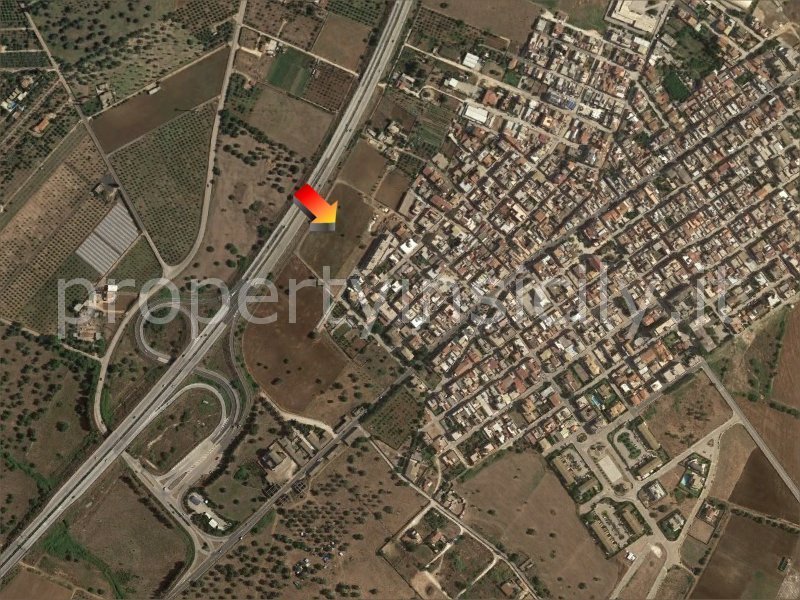
In Cassibile fraction of Syracuse, 750 meters from the highway junction of Cassibile (A18 highway), we propose for sell interesting plot of land of 14.337 sq.m. with productive and commercial and directional destination.
The land for sale is within area D3.1 of the master plan of the Municipality of Syracuse.
The activities allowed by the master plan of Syracuse are the following: wholesale trade, shopping center, public businesses such as bars, restaurants, amusement arcades, clubs, headquarters of various associations, headquarters for private cultural activities, warehouses.
Ideal for logistics bases and installations looking for visibility and ease of road connections.
To execute a construction project, there is a requirement in the land for a plan of agreed subdivision of private initiative, which requires the submission of a special project, subject to the conclusion of an agreement with the municipality.
With the subdivision plan, it is then possible to divide the land into plots to be used for building.
With a subdivision plan on the land it is possible to build a total of about 7.165 sq.m. of buildings with a maximum height of 10 meters, the area designated for parking must be no less than about 5.700 sq.m. in total.
The property is partly fenced with a tuff wall and partly with yard netting.
The area is served by public water supply and public sewer.
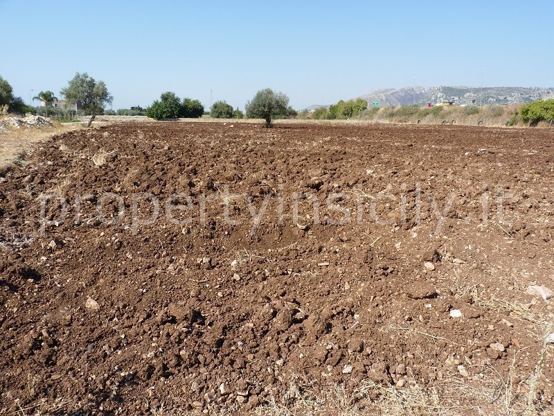
The land is perfectly flat, rectangular in shape and easy access from two paved roads.
The strategic location with proximity to the sea and the highway junction make this land an excellent investment.
The nearest airport is Fontanerossa airport in Catania, which can be reached in just under 40 minutes.
Why buy.
- Excellent investment
- Excellent location
- Close to services
- Touristic localities a few minutes away
TECHNICAL REGULATIONS FOR IMPLEMENTATION PRG MUNICIPALITY OF SYRACUSE
Summary of Article 49 Areas of new planting for craft and commercial production activities - Zone D3.1
1. Description and objectives
These are the parts of the territory on the southwestern edge of the town, located near the main roads and the railway yard.
2. Methods of execution
Conventional Lotting Plan of private initiative extended to an area of not less than 5.000 sq.m.
3. Permitted uses
The accepted destinations of use are Type B Productive and Commercial and Executive such as: wholesale trade, medium and large sales structures, shopping mall, public businesses such as: bars, restaurants, amusement arcades, clubs, headquarters of various associations, headquarters for private cultural activities, warehouses.
The destinations of uses must respect the parking requirements.
4. Intervention categories.
New construction interventions are allowed.
On existing buildings, interventions of Ordinary Maintenance, Extraordinary Maintenance, Restoration and Renovation, Type B Building Renovation and Demolition with Reconstruction are allowed.
5. Urban and building parameters
Land use index (Ut) 0,50 sq.m./sq.m.;
Maximum height (H max): 10 m;
Maximum permissible Coverage Ratio (RC): 0,40 sq.m./sq.m.;
The distance between buildings shall not be less than 20 m; Adjacent construction between buildings belonging to contiguous lots is allowed.
6. Special Provisions.
For each Agreed Subdivision Plan, the free transfer to the municipality of areas for urban services in the amount of not less than 0,80 sq.m. for each square meter of Gross Allowable Area (GLA) is prescribed. Fifty percent of these areas must be allocated for parking, even on multiple levels.
Main data on the property:
Ground area = 14.331 sq.m.
Buildable surface area = 7.165 sq.m.
Maximum building height = 10 m
Urban service areas of the municipality = about 5.730 sq.m. (of which about 2.850 sq.m. for parking)
自动翻译所用的语言
Lotto di terreno per attività produttive artigianali e commerciali a Siracusa.
A Cassibile frazione di Siracusa, a 750 metri dallo svincolo autostradale di Cassibile (autostrada A18), vendiamo interessante terreno di 14.337 mq con destinazione produttiva e commerciale e direzionale.
Il terreno in vendita ricade nell’area D3.1 del piano regolatore (PRG) del Comune di Siracusa.
Il terreno è ideale per basi logistiche ed insediamenti in cerca di visibilità e facilità di collegamenti stradali.
Le attività ammesse dal piano regolatore di Siracusa sono le seguenti: commercio all'ingrosso, centro commerciale, pubblici esercizi come bar, ristoranti, sale giochi, circoli, sedi di associazioni varie, sedi per attività culturali privati, depositi.
Per l'esecuzione di un progetto di costruzione, nel terreno c'è l'obbligo di un piano di lottizzazione convenzionato di iniziativa privata, che prevede la presentazione di un apposito progetto, subordinato alla stipula di una convenzione con il Comune di Siracusa.
Con il piano di lottizzazione è quindi possibile la divisione in lotti del terreno per poterlo destinare all'edificazione.
Con un piano di lottizzazione sul terreno si possono edificare complessivamente circa 7.165 mq di fabbricati con un'altezza massima di 10 metri, l'area destinata a parcheggio deve essere complessivamente non inferiore a 5.700 mq circa.
La proprietà risulta parzialmente recintata con muro in tufo ed in parte con rete da cantiere.
Il terreno si presenta perfettamente pianeggiante, di forma rettangolare e facile accesso da due strade asfaltate.
La zona è servita da pubblico acquedotto e pubblica fognatura.
La posizione strategica con la vicinanza al mare e allo svincolo autostradale, rendono questo terreno un ottimo investimento.
L'aeroporto più vicino è quello di Fontanarossa a Catania che si raggiunge in poco meno di 40 minuti.
Perché acquistare?
– Ottimo investimento
– Ottima posizione
– Servizi vicini
– Località turistiche a pochi minuti
NORME TECNICHE D’ATTUAZIONE PRG COMUNE DI SIRACUSA
Riassunto dell'articolo 49 Aree di nuovo impianto per attività produttive artigianali e commerciali - Zona D3.1
1. Descrizione ed obiettivi
Si tratta delle parti di territorio localizzate in prossimità delle principali vie di comunicazione stradali e dello scalo ferroviario.
2. Modalità di attuazione
Piano di Lottizzazione convenzionato di iniziativa privata esteso ad una superficie non inferiore a 5.000 mq.
3. Destinazioni ammesse
Le destinazioni d’uso ammesse sono quelle Produttiva di tipo B e Commerciale e Direzionale quali: commercio all’ingrosso, medie e grandi strutture di vendita, centro commerciale, pubblici esercizi tipo: bar, ristoranti, sale giochi, circoli, sedi di associazioni varie, sedi per attività culturali private, depositi.
Le destinazioni d’uso devono rispettare le prescrizioni relative ai parcheggi.
4. Categorie d'intervento
Sono ammessi gli interventi di Nuova costruzione.
Sull'edilizia esistente sono ammessi interventi di Manutenzione ordinaria, Manutenzione straordinaria, Restauro e risanamento conservativo, Ristrutturazione edilizia di tipo B e Demolizione con ricostruzione.
5. Parametri urbanistici ed edilizi
Indice di utilizzazione territoriale (Ut) 0,50 mq/mq;
Altezza massima (H max): 10 m;
Rapporto di Copertura massimo ammesso (RC): 0,40 mq/mq;
La distanza fra i fabbricati non deve essere inferiore a m 20, è ammessa la costruzione in aderenza fra fabbricati appartenenti a lotti contigui.
6. Disposizioni particolari
Per ciascun Piano di Lottizzazione convenzionato è prescritta la cessione gratuita al Comune di aree per servizi urbani in misura non inferiore a 0,80 mq per ogni mq di Superficie Lorda Ammissibile (SLA). Il 50% di dette aree deve essere destinata a parcheggi, anche su più livelli.
Dati principali sulla proprietà:
Superficie lotto terreno = 14.331 mq
Superficie edificabile = 7.165 mq circa
Altezza massima fabbricati = 10 m
Aree destinate a servizi urbani del Comune = 5.730 mq circa (di cui 2.850 mq circa destinati a parcheggi)